Streetcar 2 Subduction
ABOUT STREETCAR 2 SUBDUCTION
Streetcar 2 Subduction is a collection of geological field trips that take users to some of the world-class geological sites of the San Francisco Bay Area. In 1979, Clyde Wahrhaftig created a geology tour of the San Francisco Bay Area, which was updated and published by AGU as “A Streetcar to Subduction and Other Plate Tectonic Trips by Public Transport in San Francisco” in 1984. Forty years later, as part of AGU’s Centennial, the “Streetcar” tours have been revised, with new trips added, and old exposures that have vanished removed, taking what once was a print book and turning it into a digital experience through Google Earth.
Streetcar 2 Subduction is designed for anyone to explore the geology of the San Francisco Bay area with their phone or cellular enabled device and the Google Earth App. The experience is modular and can take anyone from a few hours to a few days depending on how many trips and stops they would like to make. Many of the trips are accessible through public transportation, but a few outlying trips are best reached by driving. The trip can also be explored by those at home through their internet browser.
Angel Island
Recommended time for trip: One day, all day. Ferry access begins mid-morning and concludes around 3pm. See the ferry service’s website for specific times for crossings via Tiburon and San Francisco.
Accessibility: The views and some outcrops are visible from the paved road which circles the island. Beach and cliff outcrops require scrambling up and down steep trails. Beware of the tides. The sites furthest from the ferry landing are roughly 2.5 km walk away.
Summary: Several of the most spectacular geological highlights of the Bay Area can be found around the western shoreline of Angel Island where blueschists and serpentinites are situated between historic military buildings. These rocks contain minerals that only form when buried deeply at relatively cool temperatures, conditions only found on Earth in subduction zones. Both the passenger ferry ride to the island and the trails around the island provide remarkable views of the city, the Golden Gate Bridge, Alcatraz Island, Tiburon Peninsula, and the surrounding Bay Area.
Park rules: Angel Island State Park prohibits flying drones or collecting rocks without a permit.BE CAREFUL! Poison oak is common on Angel Island, particularly in the undergrowth off the trails.
Angel Island
Take TripCorona Heights
Recommended time for trip: Allow 1 to 2 hours.
Accessibility: Walking is predominantly on unpaved trails around the park, which is located on top of a hill. Accessing sites near the top of the hill requires a short but steep hike. Trails may be muddy after rains. Some sites can be accessed from paved roads and require minimal/no walking from a car dropoff.
Summary: Corona Heights Park is an urban park in the Castro District of San Francisco. It is centered on a hill underlain by reddish-brown chert, a sedimentary rock that is resistant to erosion. Chert is very well exposed in a number of places, including the sites of a former quarry and brick factory. Today, the quarry floors provide flat areas for playgrounds, tennis courts, picnic areas and the Randall Museum, while the quarry walls provide superb exposures of chert and deformation structures including folds and and faults. There are also amazing panoramic views from the top of the hill of the city of San Francisco and wider Bay Area.
Park rules: Sampling is strictly prohibited without prior permission in City of San Francisco Parks. Please be respectful of the daycare next to the park where the Corona Heights Fault is exposed.
BE CAREFUL! Poison oak is present in the scrub areas - stick to the trails.
Corona Heights
Take TripGlen Canyon Park
Recommended time for trip: 1-2 hours
Accessibility: O'Shaughnessy Boulevard is a windy, moderately steep urban road with a well-maintained sidewalk along its east side. There are cross-walks with motion activated flashing lights at both the downhill (Malta Dr.) and uphill (Del Vale Ave.) ends of the road. Guardrails separate the sidewalk from fast-moving traffic in many areas. Accessing the outcrops up close would require crossing O'Shaughnessy Boulevard where it lacks a cross-walk: beware of fast-moving traffic. The base of the outcrops is uneven, rocky ground, and also a site where litter accumulates.
Summary: Glen Canyon Park is a forested valley maintained by the city of San Francisco as a public park. Along the west side of the park is a twisty road called O'Shaughnessy Boulevard, which has some worthy outcrops of folded chert and views of several interesting geomorphic features.
Park Rules: Sampling is strictly prohibited without prior permission in City of San Francisco Parks.
Glen Canyon Park
Take TripHayward Fault at Central Park
Accessibility: In general, the park offers paved walking paths which allow access to all key features on this tour. Access to the interior of the old Fremont City Hall is by appointment only.
Park Rules: The city of Fremont prohibits sampling within their parks. Flying drones anywhere within Fremont city parks is prohibited.
Summary: Self-guided tour of Hayward Fault in Fremont’s Central Park where you will observe a seismic movement along a fault (this means the fault moves very slowly without the occurrence of earthquakes) and landforms that are produced by this movement. The rate of movement on the Hayward Fault is ~5 mm/yr. You will see how left and right bends along a right lateral strike-slip fault modify the landscape in real time, forming hills, depressions and offsets in the landscape and on manmade structures.
Hayward Fault at Central Park
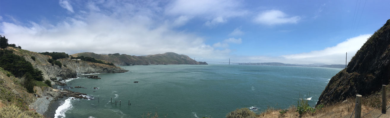
Take TripMarin Headlands
Recommended time for trip: Exploring all of the sites on the Marin Headlands would require a full-day trip but smaller areas or individual sites can be visited in an hour. Tailor this trip to meet your time budget.
Accessibility: Kirby Cove and Black Sands Beach are accessed via a short hike along a graded to unpaved trails. Return hikes for both beaches involve a 20 to 30-minute sustained uphill hike. Sites along Conzelman Rd are generally on paved footpaths at the side of the road, but most are very close to the narrow road so take great care for traffic. Rodeo Cove sites are accessed by walking along a sandy or gravelly beach. Toilets are available at Kirby Cove, Rodeo Cove, and along Conzelman Road.
Summary: The Marin Headlands are home to some classic sites in Bay Area geology, as well as incredible views of the famous Golden Gate Bridge from the north. Kirby Cove is located a few hundred meters west of the Golden Gate Bridge at the south end of the Marin Headlands peninsula. Go there to see pillow basalt, bedforms in ribbon chert, remarkable chevron folds in chert, and for the incredible backdrop of the Golden Gate Bridge. Follow Conzelman Rd up the hill for exceptional examples of chevron folds, thrust faults, and yet more views of the bridge and Bay Area beyond. At Rodeo Cove, thrust faults repeat the seafloor stratigraphy and a seamount is in contact with the seafloor slices along a steep, young fault parallel to the San Andreas (which is just offshore).
Park rules: The Marin Headlands are part of the Golden Gate National Recreation Area. Sampling is strictly prohibited without prior permission.
Marin Headlands
Take TripRing Mountain
Recommended time for trip: 3 hours minimum.
Accessibility: Walking is predominantly on paved or gravel fire roads with shortcuts on single track trails. Maximum elevation change is about 50 meters if starting at Taylor Road and 180 meters if starting from Phyllis Ellman trailhead. Stops 1-11 from Taylor Rd ~ 2.5 km walking.
Summary: Ring Mountain Open Space Preserve, on a grassy hill in Marin County, is a world-famous site for its outcrops of a variety of metamorphic rocks. Metamorphic rocks are those which have changed physical or chemical character since they originally formed due to extreme conditions deep within the Earth. At Ring Mountain, the rocks reveal high-pressure and low-temperature conditions of a subducting oceanic plate. Unusual serpentinite bedrock at this location produces magnesium-rich soils which are home to a number of endemic wild flowers. There are also exceptional views of the San Francisco Bay.
Park rules: Marin County Open Space prohibits flying drones or collecting rocks without a permit.
BE CAREFUL! Poison oak is common on Ring Mountain, particularly on the floor adjacent to many of the blocks of rock highlighted below.
Ring Mountain
Take TripSan Andreas Fault at Sanborn County Park
Recommended time for trip: 2.5 hours minimum.
Accessibility: Public access along paved roads and trails. A park fee may be required. Minimal elevation gain, ~5 m.
Summary: The San Andreas Fault, the boundary between the North American Plate and the Pacific Plate, cuts through Sanborn County Park near Saratoga, California. This section of the San Andreas Fault is called the Santa Cruz Mountain section. Sanborn County Park is a great place to see tectonic geomorphic landforms such as sagponds, streams and alluvial fans. These tectonic geomorphic landforms are evidence of past movements of the San Andreas Fault. By observing how much the landforms are offset from their original position and determining how old they are, it is possible to calculate the rate of fault movement as a result of earthquakes.
Park rules: Santa Clara County Parks prohibit flying drones, conducting field work and collecting rocks without a permit.San Andreas Fault at Sanborn County Park
Take TripSan Andreas Fault along Hwy 280
Recommended time for trip: 1.5 hours.
Accessibility: Walking is on paved road or trail. Minimal elevation gain, ~5 m. Note that to arrive at Feature 1 access is only possible on Highway 280. When coming from San Francisco, exit Edgewood and get back on the Highway 280 going North. Take the first exit, exit 30 toward Vista Point.
Summary: Along the transform plate boundary between the Pacific and North American tectonic plates is a system of strike-slip faults that slice urban northern California into blocks. The movement of the blocks past one another produces earthquakes, the greatest natural hazard to affect this region. The San Andreas Fault is the best known and the most hazardous of these faults. Several sites around the Peninsula along highway 280 provide the rare opportunity to see surface evidence of this fault, the landforms it has produced, and ways to evaluate the ongoing earthquake hazard.
Park rules: San Mateo County Parks prohibit flying drones, conducting field work and collecting rocks without a permit.San Andreas Fault along Hwy 280
Take TripFort Mason
Summary: Fort Mason is a former United States Army post located in the northern Marina District, alongside San Francisco Bay. Today it is part of the Golden Gate National Recreation Area and the site of several cultural facilities. Coastal outcrops display typical Franciscan graywacke sandstone of the Alcatraz Terrane, as well as views of the bay islands and Marin County. Fort Mason features a sandstone outcropping which is an excellent example of prehnite-pumpellyite facies metamorphism..
Trip to launch in early 2020
Fort Mason
Coming soonMarshall’s Beach
Summary: Accessed by taking the Batteries to Bluff’s trail downhill, Marshall’s beach offers some of the best views of the Golden Gate Bridge in the city. The beach itself offers excellent examples of serpentinite and melange blocks.
Trip to launch in early 2020
Marshall’s Beach
Coming soonTrip overview
How to use this guide
This guide has been developed using the creation tools in Google Earth and is intended to provide locations of sites of geological interest and information to help users explore and learn about the geology. The guide content, which includes original imagery, video, and other digital media can be accessed and explored from a desktop computer or mobile device. Much of the content requires internet connectivity for access, so cellular data is recommended for use in the field.
Streetcar 2 Subduction is accessed differently depending on if you are in the field or at home. For field use, the guide is accessed with a combination of the Google Earth app and the Google Maps app. You should download both before going into the field. For home users, the Google Chrome browser is used to access the experience.
For field use:
For home use:
Individual trips can be accessed by clicking on “Take Trip” from the Streetcar Trips tab. Clicking “Take trip” will automatically launch the trip in either the Google Earth App (field use) or Google Chrome (home use). Each trip is organized into a series of sites, which are listed in a table of contents. Choose “Present” to view the sites in the order listed, or select individual sites by name from the contents.
To begin a trip in the field, navigate to the sites that provide access or parking by clicking on the “Directions” link in the app. This will launch Google maps or your preferred map app, which will provide directions. Once on-site, use the blue location icon on the map to locate yourself and navigate from site to site. Tours contain multiple sites of interest, but there are lots of exposures and geological features that are not highlighted as sites in the tours so stay on the lookout for additional points of interest.
About Clyde
To learn more about Clyde Wahrhaftig, check out an EOS article that AGU published in 2019. The article highlights Clyde’s legacy, continuing impact in geology and how his 1984 guide was reimagined for the digital age.
Acknowledgements
-
Clyde Wahrhaftig and his family.
-
Authors Jamie Kirkpatrick (McGill University), Callan Bentley (Northern Virginia Community College), Kim Blisniuk (San Jose University), Christie Rowe (McGill University) and John Wakabayashi (Freson University)
-
Google Earth
-
The AGU Celebrate 100 Grants program.
-
Brooks Hanson (Executive Vice President of Science, AGU)
-
Jenny Lunn (Director, Publications, AGU)
-
Derek Sollosi (Video Producer, AGU)
-
Brandon Bobisink, (Project Manager, AGU)
Thanks also to :
-
Amy Hagiwara (San Jose State University) for drafting many of the illustrations
-
Sean Mulcahy (Western Washington University) for consulting on pressure-temperature conditions of metamorphism for Ring Mountain rocks.
-
Samantha Carruthers (McGill University) for photos of Turtle Rock and serpentinite matrix melange on Ring Mountain.
-
Steve Rowe for photos of prehnite-pumpellyite grade sandstones at San Quentin